| £ s d | |
| A warrant for the Surveyor of the Highways. | 0.3.0 |
| To John Tate for mending Ox Close Bridge. | 0.6.0 |
| A new Lydd Gate.(l) | 0.4.0 |
| A New Bridge upon the Carr. | 0.5.0 |
| Barnbow Bridge mending. | 0.1.7 |
| Bottom Beck Bridge mending. | 0.1.6 |
| A New Door for Potterton Bridge.(2) | 0.1.0 |
| For pursuing a Highway man | 0.1.0. |
| A new plank for Barnbow Bridge and mending the bridge at Barwick | 0.3.9 |
| £ s d | |
| To a Man Two days digging Holes in Highfield. | 0.1.6 |
| To Thomas Whitehead far Boulders. | 0. 5.0 |
| Draining watercourses several times in Long Lane. | 0. 1.6 |
| A man backing the way in Little Field. | 0. 1.0 |
| Drink when Loading Broad Causeway Stones. | 0. 2.0 |
| William Tate Bill for paving. | 0.19.6 |
| To John Tate for laying Broadstone Causeway 281 yards at 4d a yard | 4.13.8 |
| To John Tate for Briggstones and wall stones. | 0. 7.6 |
| For ale given to labourers. | 0. 0.6 |
| To Drink for labourers. | 0. 5.4 |
| To laying tbe Roads. | 0. 3.0 |
| To Drink at the same time. | 0. 7.4 |
| Paid for an indictment. | 0.0.6 |
| £ s d | |
| Sir Thomas Gascoigne, Bart., Parl1ngton. | 25.0.0 |
| LL.Fox, Esq., Bramham Park. | 10.0.0 |
| Edward Wilkinson, Potterton. | 15.0.0 |
| John Crosland, Scholes. | 5.0.0 |
| James and Thomas Lumb of Barwick. | 5.5.0 |
| James Hodgson, Rector of Barwick | 10.0.0 |
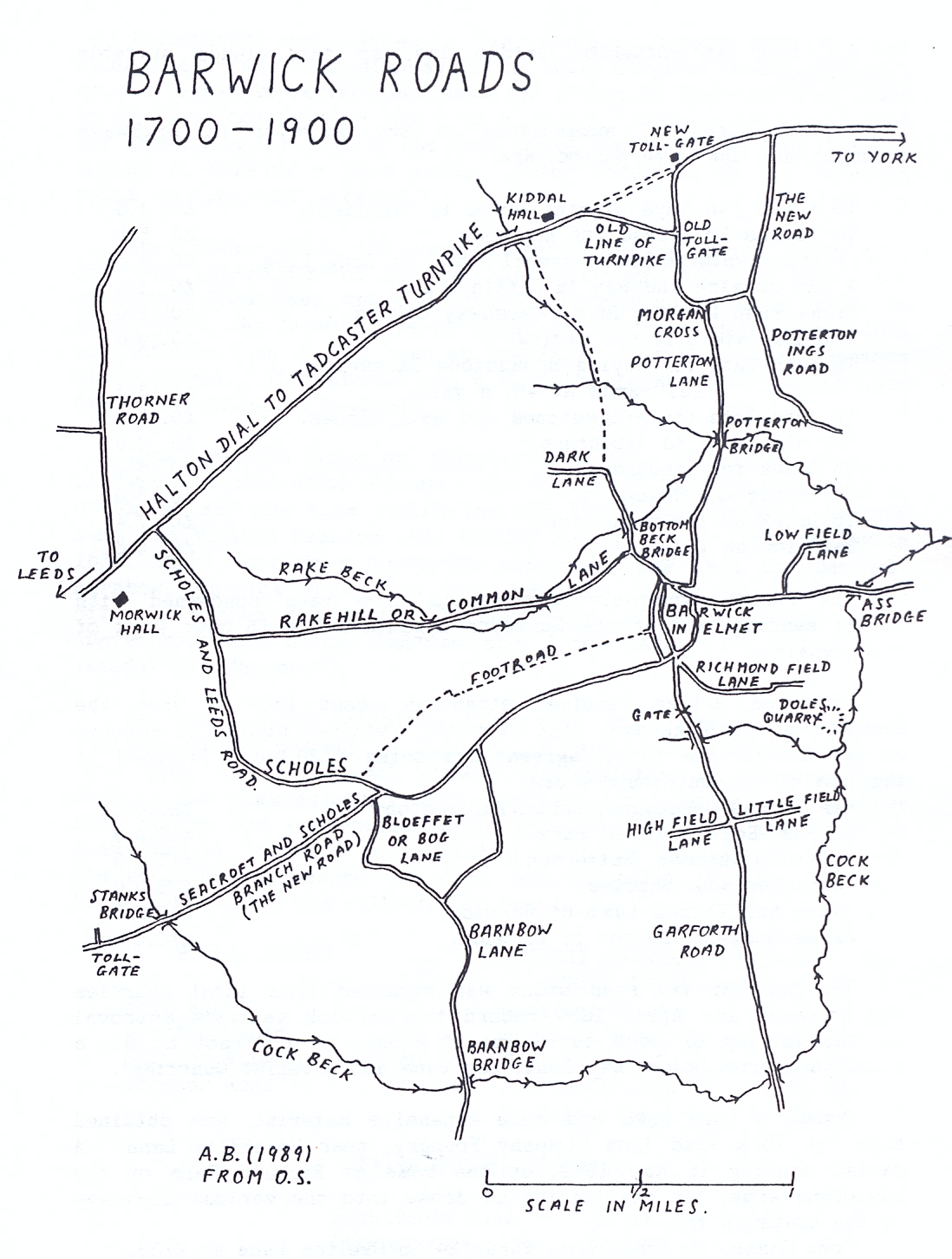
| PUBLIC ROADS | PRIVATE CARRIAGE WAYS AND | ||
| PUBLIC BRIDLE WAYS | |||
| York Road | 45 ft. | Garforth Road | 45 ft. |
| Aberford Road | 45 ft. | Rakehill Road | 40 ft. |
| Scholes & Leeds Road | 45 ft. | Barnbow Lane | 30 ft. |
| Thorner Road | 45 ft. | Low Field Lane | 20 ft. |
| Potterton Ings Road | 18 ft. |
| PRIVATE CARRIAGE WAYS | |
| High Field Lane | 40 ft. |
| Little Field Lane | 30 ft. |
| Richmond Field Lane | 30 ft. |
| FOOT ROADS | |
| From Barwick Church to the South End of the Town. | |
| From Potterton to Kiddal Hall. | |
| From Barwick to Scholes. |
| DEPOSIT CLAIMANT'S NAME | NAME OF LANE | PURCHASE MONEY |
| £. s. d | ||
| J.B.Westwood | Low Field and Chapel Lanes | 1.10.0 |
| Geo. Armitage | Potter ton Lane - Morgan Cross | 0.11.0 |
| do. | Bar Lane to New Road | 0. 3.0 |
| Alt White | Garforth Road | 2. 2.0 |
| S.Braithwaite | Common Lane to Workhouse | 0. 5.0 |
| Leeds and Tadcaster
From Ass Bridge through Barwick to the New Road, forward
through Stanks to the boundary. From New Road through Scholes to Leeds-Tadcaster turnpike. The highway through Cross Gates, and the road from Barwick to Garforth to be left open for further consideration. N.B. The Seacroft and Scholes Branch Road constructed in 1840, was referred to at that time as the 'New Road' |
Tony Cox |